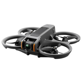
 DJI Air 3 Drone Description and Specifications
Since this aircraft has a takeoff weight of 100g or more, it is subject to the " Flight Rules for Unmanned Aerial Vehicles " in Japan. Additionally, after purchase, you will need to register with the Drone Registration System . See below for details.
What is DJI Air 3 Drone

DJI Air 3 Price
-
DJI Air 3

DJI 2023/07/25 USD1099.00
Weight:720g/ Maximum resolution:4K 100fps/ Flight time:42 min. Medium Tele & Wide-Angle Dual Primary Cameras - DJI Air 3 features dual 1/1.3-inch-sensor cameras: a 24mm f/1.7 wide-angle and a 70mm f/2.8 medium tele for more creative focal-length options. 46-Min Max Flight Time - A 46-minute max flight time is a 48% increase compared to DJI Air 2S, providing more time and freedom to fully unleash aerial creativity.
-
DJI Fly

DJI Photo / Video Free
It is a control application for DJI Mavic Mini drone. The DJI Fly app is designed to make it easy for anyone to fly a drone. Intuitive interface and spacious camera view. An easy-to-understand flight tutorial that allows you to quickly master flight operations. A search function that allows you to see a good-looking flight location and nearby GEO areas. Advanced editing features including various tools and templates that can be edited and shared immediately.
view details(App Store)Initial settings for DJI Fly appHow to use DJI Fly app
DJI Air 3 Specifications
| Takeoff Weight | 720 g |
|---|---|
| Dimensions | Folded (without propellers): 207×100.5×91.1 mm (L×W×H) Unfolded (without propellers): 258.8×326×105.8 mm (L×W×H) |
| Max Ascent Speed | 10 m/s |
| Max Descent Speed | 10 m/s |
| Max Horizontal Speed (at sea level, no wind) | 21 m/s 19 m/s in EU regions. |
| Max Takeoff Altitude | 6000 m |
| Max Flight Time | 46 minutes |
| Max Hovering Time | 42 minutes |
| Max Flight Distance | 32 km |
| Max Wind Speed Resistance | 12 m/s |
| Max Pitch Angle | 35° |
| Operating Temperature | -10° to 40° C (14° to 104° F) |
| Global Navigation Satellite System | GPS + Galileo + BeiDou |
| Hovering Accuracy Range | Vertical: ±0.1 m (with vision positioning) ±0.5 m (with GNSS positioning) Horizontal: ±0.3 m (with vision positioning) ±0.5 m (with high-precision positioning system) |
| Internal Storage | 8 GB |
| Image Sensor | Wide-Angle Camera: 1/1.3-inch CMOS, Effective Pixels: 48 MP Medium Tele Camera: 1/1.3-inch CMOS, Effective Pixels: 48 MP |
|---|---|
| Lens | Wide-Angle Camera FOV: 82° Format Equivalent: 24 mm Aperture: f/1.7 Focus: 1 m to ∞ Medium Tele Camera FOV: 35° Format Equivalent: 70 mm Aperture: f/2.8 Focus: 3 m to ∞ |
| ISO Range | Video Normal and Slow Motion: 100-6400 (Normal) 100-1600 (D-Log M) 100-1600 (HLG) Night: 100-12800 (Normal) Photo 100-6400 (12 MP) 100-3200 (48 MP) |
| Shutter Speed | Wide-Angle Camera 12MP Photo: 1/16000-2 s (2.5-8 s for simulated long exposure) 48MP Photo: 1/8000-2 s Medium Tele Camera 12MP Photo: 1/16000-2 s (2.5-8 s for simulated long exposure) 48MP Photo: 1/8000-2 s |
| Max Image Size | Wide-Angle Camera: 8064×6048 Medium Tele Camera: 8064×6048 |
| Still Photography Modes | Wide-Angle Camera Single Shot: 12 MP and 48 MP Burst Shooting: 12 MP, 3/5/7 frames; 48 MP, 3 frames Automatic Exposure Bracketing (AEB): 12 MP, 3/5 frames; 48 MP, 3 frames at 0.7 EV step Timed: 12 MP, 2/3/5/7/10/15/20/30/60 s; 48 MP, 5/7/10/15/20/30/60 s Medium Tele Camera Single Shot: 12 MP and 48 MP Burst Shooting: 12 MP, 3/5/7 frames; 48 MP, 3 frames Automatic Exposure Bracketing (AEB): 12 MP, 3/5 frames; 48 MP, 3 frames at 0.7 EV step Timed: 12 MP, 2/3/5/7/10/15/20/30/60 s; 48 MP, 5/7/10/15/20/30/60 s |
| Photo Format | JPEG/DNG (RAW) |
| Video Resolution | Wide-Angle Camera: H.264/H.265 4K: 3840×2160@24/25/30/48/50/60/100*fps FHD: 1920×1080@24/25/30/48/50/60/100*/200*fps 2.7K Vertical Shooting: 1512×2688@24/25/30/48/50/60fps FHD Vertical Shooting: 1080×1920@24/25/30/48/50/60fps Medium Tele Camera: H.264/H.265 4K: 3840×2160@24/25/30/48/50/60/100*fps FHD: 1920×1080@24/25/30/48/50/60/100*/200*fps 2.7K Vertical Shooting: 1512×2688@24/25/30/48/50/60fps FHD Vertical Shooting: 1080×1920@24/25/30/48/50/60fps |
| Video Format | MP4 (MPEG-4 AVC/H.264, HEVC/H.265) |
| Max Video Bitrate | H.264/H.265: 150 Mbps |
| Supported File System | exFAT |
| Color Mode and Sampling Method | Wide-Angle Camera Normal: 8-bit 4:2:0 (H.264/H.265) HLG/D-Log M: 10-bit 4:2:0 (H.265) Medium Tele Camera Normal: 8-bit 4:2:0 (H.264/H.265) HLG/D-Log M: 10-bit 4:2:0 (H.265) |
| Digital Zoom | Wide-Angle Camera: 1-3x Medium Tele Camera: 3-9x |
| Stabilization | 3-axis mechanical gimbal (tilt, roll, pan) |
|---|---|
| Mechanical Range | Tilt: -135° to 70° Roll: -50° to 50° Pan: -27° to 27° |
| Controllable Range | Tilt: -90° to 60° Pan: -5° to 5° |
| Max Control Speed (tilt) | 100°/s |
| Angular Vibration Range | ±0.0037° |
| Sensing Type | Omnidirectional binocular vision system, supplemented with an infrared sensor at the bottom of the aircraft |
|---|---|
| Forward | Measurement Range: 0.5-18 m Detection Range: 0.5-200 m Effective Sensing Speed: Flight Speed ≤ 12 m/s FOV: Horizontal 90°, Vertical 72° |
| Backward | Measurement Range: 0.5-18 m Effective Sensing Speed: Flight Speed ≤ 12 m/s FOV: Horizontal 90°, Vertical 72° |
| Lateral | Measurement Range: 0.5-30 m Effective Sensing Speed: Flight Speed ≤ 12 m/s FOV: Horizontal 90°, Vertical 72° |
| Upward | Measurement Range: 0.5-18 m Effective Sensing Speed: Flight Speed ≤ 6 m/s FOV: Front and Back 72°, Left and Right 90° |
| Downward | Measurement Range: 0.3-14 m Effective Sensing Speed: Flight Speed ≤ 6 m/s FOV: Front and Back 106°, Left and Right 90° |
| Operating Environment | Forward, Backward, Left, Right, and Upward: Surfaces with discernible patterns and adequate lighting (lux > 15) Downward: Surfaces with discernible patterns, diffuse reflectivity > 20% (e.g. walls, trees, people), and adequate lighting (lux > 15) |
| 3D Infrared Sensor | Measurement Range: 0.1-8 m (reflectivity > 10%) FOV: Front and Back 60°, Left and Right 60° |
| Video Transmission System | O4 |
|---|---|
| Live View Quality | Remote Controller: 1080p/30fps, 1080p/60fps |
| Operating Frequency | 2.4000-2.4835 GHz 5.170-5.250 GHz 5.725-5.850 GHz |
| Transmitter Power (EIRP) | 2.4 GHz: < 33 dBm (FCC) < 20 dBm (CE/SRRC/MIC) 5.1 GHz: < 23 dBm (CE) 5.8 GHz: < 33 dBm (FCC) < 30 dBm (SRRC) < 14 dBm (CE) |
| Max Transmission Distance (unobstructed, free of interference) | FCC: 20 km CE: 10 km SRRC: 10 km MIC: 10 km |
| Max Transmission Distance (unobstructed, with interference) | Strong Interference: urban landscape, approx. 1.5-4 km Medium Interference: suburban landscape, approx. 4-10 km Low Interference: suburb/seaside, approx. 10-20 km |
| Max Transmission Distance (obstructed, with interference) | Low Interference and Obstructed by Buildings: approx. 0-0.5 km Low Interference and Obstructed by Trees: approx. 0.5-3 km |
| Max Download Speed | O4: 10 MB/s (with DJI RC-N2 Remote Controller) 10 MB/s (with DJI RC 2) Wi-Fi 5: 30 MB/s* |
| Lowest Latency | Aircraft + Remote Controller: approx. 120 ms |
| Antenna | 6 antennas, 2T4R |
| Protocol | 802.11 a/b/g/n/ac |
|---|---|
| Operating Frequency | 2.400-2.4835 GHz 5.725-5.850 GHz |
| Transmitter Power (EIRP) | 2.4 GHz: < 20 dBm (FCC/CE/SRRC/MIC) 5.8 GHz: < 20 dBm (FCC/SRRC) < 14 dBm (CE) |
| Protocol | Bluetooth 5.2 |
|---|---|
| Operating Frequency | 2.400-2.4835 GHz |
| Transmitter Power (EIRP) | < 10 dBm |
| Capacity | 4241 mAh |
|---|---|
| Weight | Approx. 267 g |
| Nominal Voltage | 14.76 V |
| Max Charging Voltage | 17 V |
| Type | Li-ion 4S |
| Energy | 62.6 Wh |
| Charging Temperature | 5° to 40° C (41° to 104° F) |
| Charging Time | Approx. 80 minutes (with DJI 65W Portable Charger) Approx. 60 minutes (with DJI 100W USB-C Power Adapter and Battery Charging Hub) |


